|
|
||||||||||
|
Your portal to outdoor sports in California |
||||||||||
|
CALIFORNIA'S ON-LINE MAGAZINE FOR OUTDOOR SPORTS
|
||||||||||
|
ANNO NUEVO STATE RESERVE DAYHIKE
Other interesting aspects of the reserve are the many whale bones found here as well as large shell mounds remaining from the inhabitation of the Ohlone Indians. Often the spouts of Gray Whales can be viewed from some of the trails.
BERRY CREEK FALLS DAYHIKE
Located within the Santa Cruz Mountains approximately one hour south of San Francisco, Big Basin is accessible inland via Highway 9 and from the beach side via scenic Highway 1 approximately 30 minutes north of Santa Cruz.
The hike to Berry Creek Falls is approximately seven miles. You have a choice of walking the fire road which follows the valley floor for about six and a half miles through Big Basin Park to the end where the trail veers off to the south east (well marked) about a half mile to the falls. Or you can follow a trail that crosses the fire road several times during the hike.
|
|
|||||||||
|
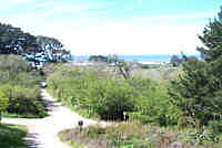
WILDER RANCH STATE PRESERVE DAY HIKE
PHOTO BY GENE RAFFANTI 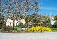 Located about 4 miles north of Santa Cruz along Highway 1, Wilder Ranch is designated both as a State Reserve and a State Park. Wilder Beach was designated a reserve to protect the nesting sites of the Snowy Plover.
A day at Wilder can be fun for the whole family. This area was a working ranch for over 100 years and the victorian style ranchhouse, barns and other outbuildings have been preserved for the education and enjoyment of visitors. Kids will enjoy walking around the ranch feeding and petting many of the animals. Don't skip the visitor center where local animal life is displayed, points of interest are highlighted, and books of local interest are offered for sale.
NATURAL BRIDGES STATE BEACH DAY HIKE
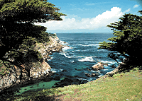
POINT LOBOS DAY HIKE
The Point Lobos area has been called "the greatest meeting of land and water in the world" by Landscape artist Francis McComas. With its rugged cliffs and sparkling blue waters, Point Lobos has long been a favored Hollywood location. It's picturesque cliffs, trails, and woods offer several unique hiking experiences.
There are about 20 miles of well marked, and easy to follow, trails in the park. Our featured hikes are on the beach side of the highway, so the terrain is fairly level with no serious climbs.
|
||||||||||
|
|
|
|||||||||
Bad RequestYour browser sent a request that this server could not understand.The request line contained invalid characters following the protocol string.
|
||||||||||
|
|
||||||||||
|
All rights reserved
Calsports Webmaster |
||||||||||
 Located 40 miles south of San Francisco and 20 miles north of Santa Cruz on Highway 1, Ano Nuevo Reserve is a great hike any time of year, however in the winter months the huge elephant seals occupy the area beaches and sand dunes as their breeding ground and they again come ashore in the spring and summer to molt.
 Point Lobos State Reserve is located about 4 miles south of Carmel on State Highway 1 at the southern end of Carmel Bay.
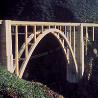 Andrew Molera State Park is located about 30 miles south of Carmel in the heart of Big Sur about 7 miles south of the world famous Bixby Bridge on Highway 1. There is a parking lot on the left where the